 Cyber Badger Research Blog
 Strip Maps of the Manchester Ship Canal
 I am a big fan of unusual modes of mapping. One cartographic design approach that has long fascinated me is the linear route chart, known as the 'strip map'. A few years ago for my PhD research I wrote a draft chapter considering how the process of data routing through the Internet could be represented using the strip map concept, and also thought of as a kind of 'Songline'. (Somewhat sadly, this work did not make into the finished thesis as it was not deemed worthy by my PhD examiners!)
Anyway, the cartographic scholar Alan MacEachren has also written some key articles describing the nature and utility of strip maps a couple of decades ago. In particular, he usefully delineated the essential characteristics of strip maps in his 1986 article, setting out a five-level schema of ‘stripness’:
- linear form omitting geographic detail beyond a narrow route corridor,
- orientation with a direction other than north at the top, not orientated along a cardinal direction,
- lack of concern with geographic orientation; no indication of cardinal directions given,
- relaxation of planimetric accuracy to allow variations in scale and orientation between different parts of the map so as to maintain the linear format of the route,
- strict linear representation of route way with complete disregard to consistent scale or direction.
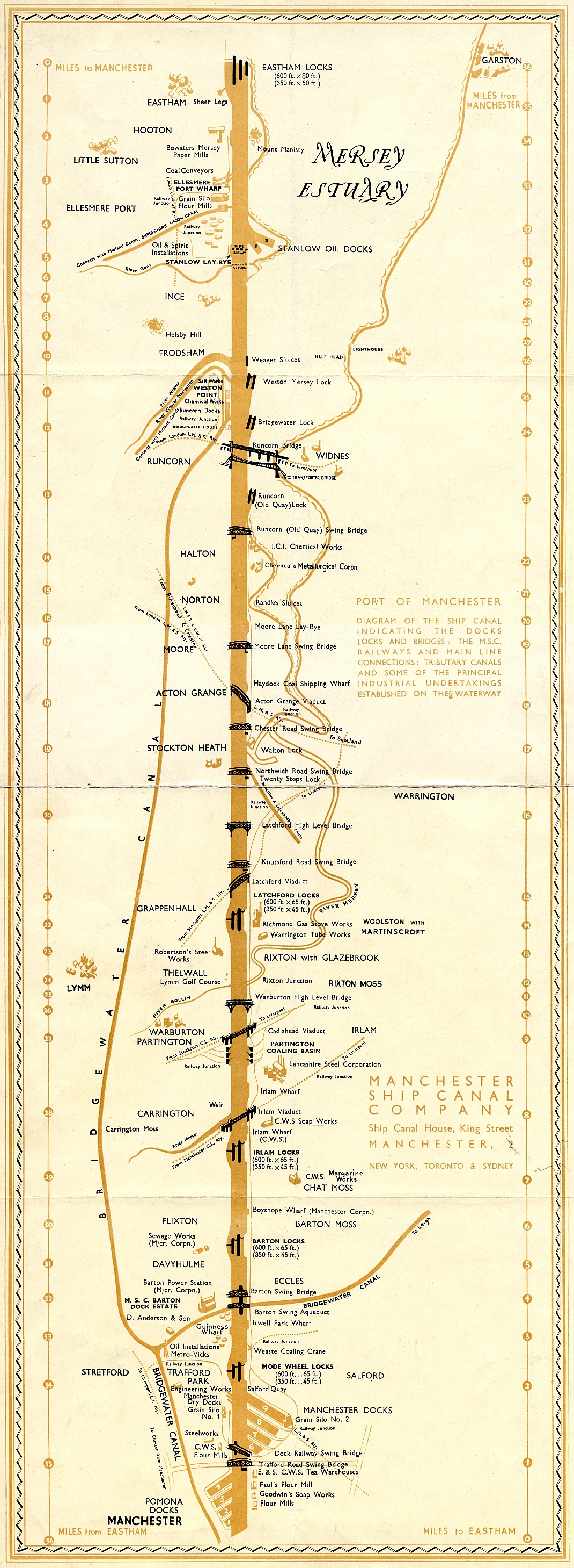
 Interestingly multiple versions of strip maps were also published through the twentieth century by the owners of the Manchester Ship Canal to promote its facilities. The linear nature of the 36 mile long canal made it well suited to being displayed in abstract form that eliminates much geographical reality for sake of clarity. The first example map, shown above, is from 1923 and represents the Ship Canal as a dead straight orange line from the Mersey down to Manchester Docks. All the locks and different bridge crossings are neatly delineated, along with
small icons locating important canal side industrial facilities, such as
Robertson's Steel Works at Thelwell. (The location of Lymm golf course is also shown for some reason.) Wider loops of the older Bridgewater Canal the River Mersey that accompany the MSC are also depicted.
Interestingly multiple versions of strip maps were also published through the twentieth century by the owners of the Manchester Ship Canal to promote its facilities. The linear nature of the 36 mile long canal made it well suited to being displayed in abstract form that eliminates much geographical reality for sake of clarity. The first example map, shown above, is from 1923 and represents the Ship Canal as a dead straight orange line from the Mersey down to Manchester Docks. All the locks and different bridge crossings are neatly delineated, along with
small icons locating important canal side industrial facilities, such as
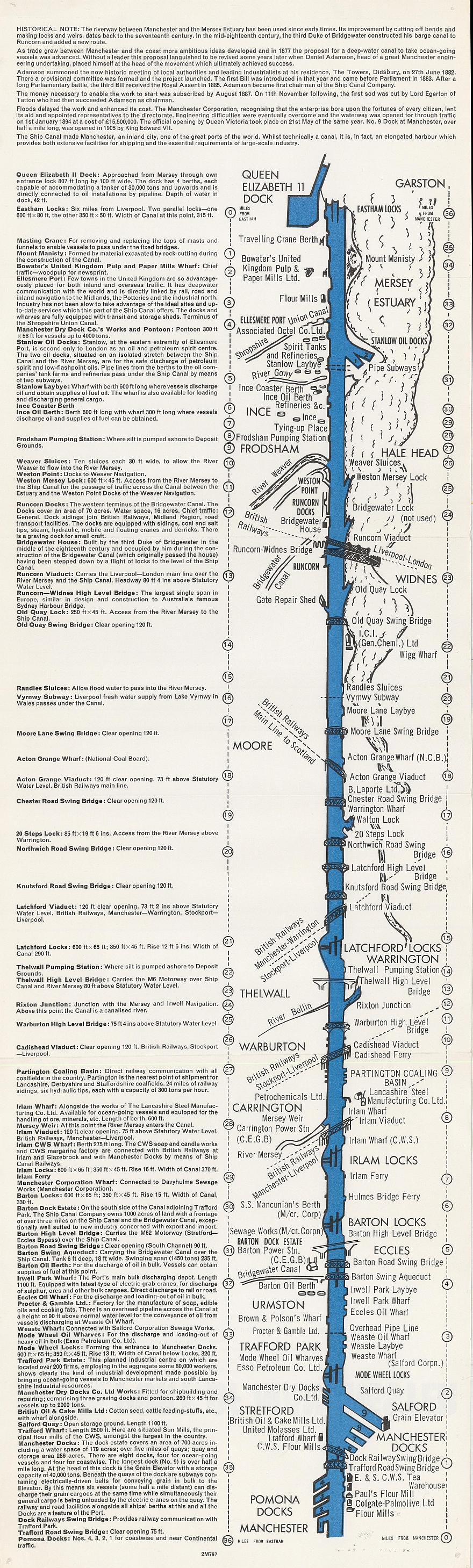
Robertson's Steel Works at Thelwell. (The location of Lymm golf course is also shown for some reason.) Wider loops of the older Bridgewater Canal the River Mersey that accompany the MSC are also depicted. The second example, shown on the right, is a somewhat more simplified in informational content and also slightly less 'strip' straight, with the cartographer choosing to represent at least some of the sinuosity of the canal's real geography. The result is rather cartoon like, in keeping with its role as the key illustration in a tourist leaflet to guide people taking an 'educational cruise' down the Manchester Ship Canal in the mid 1960s. (This image is scanned from an original copy of the leaflet in the Brian Robinson Archive, courtesy of Lloyd Robinson.)


Further reading:
- More conventional historical maps of the Manchester Ship Canal,
- MacEachren A M, 1986, "A linear view of the world: strip maps as a unique form of cartographic representation", The American Cartographer, 13(1): 7-26,
- MacEachren A M and Johnson G B, 1987, "The evolution, application and implications of strip format travel maps", The Cartographic Journal, 24(2): 147-158.
posted by martin at 7:08 AM
![]()


3 Comments:
I'm interested in your dating of the first map to 1923. Do you have a definitive source for that? I ask because the typeface used looks like Gill Sans, which wasn't released until 1928.
It's not often that I read such good posts.
Thanks for describing such things on your blog. I would like to thank you for such a good post
randki
Post a Comment
<< Home